Racetrack Playa, Death Valley
GPS: 36°40’37.10”N, 117°33'43.04"W
Interesting Stats:
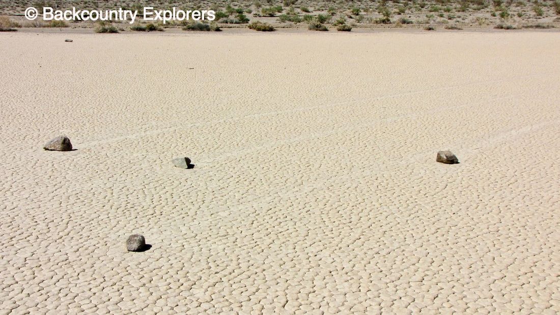
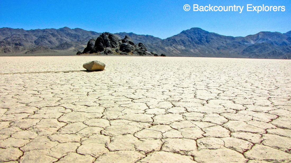
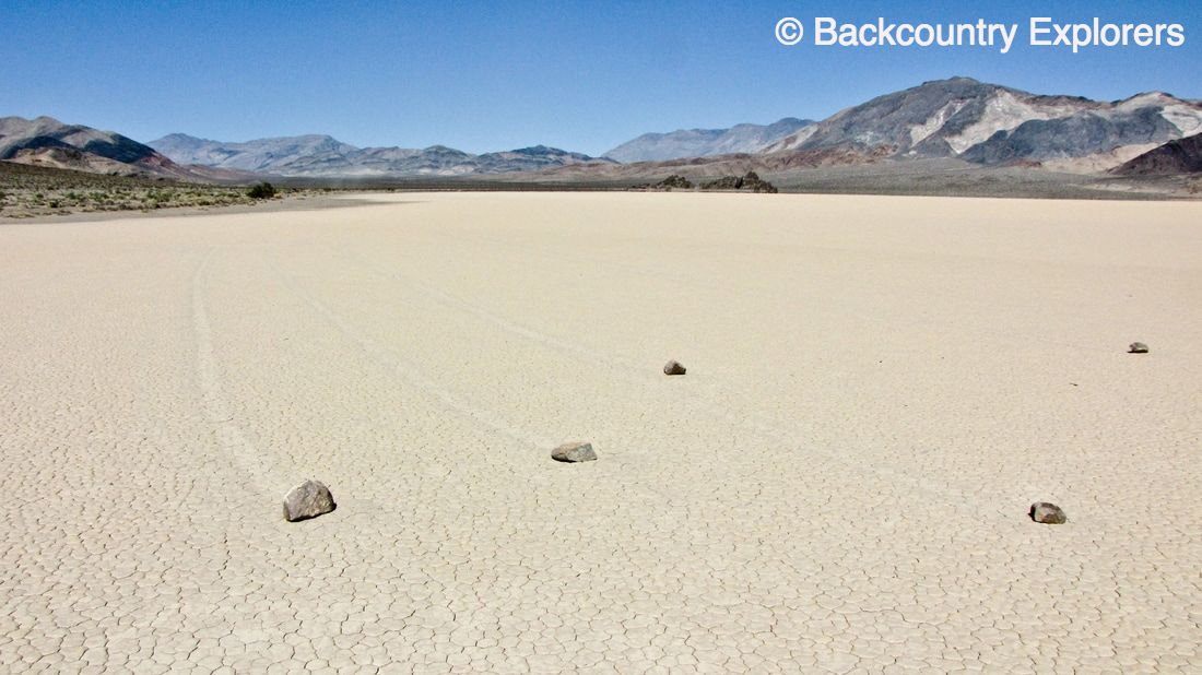
- Rocks weighing up to seventy pounds slide or sail across the playa hundreds of yards making "tracks" as they move.
- The playa is 2.8 mile long by 1.3 miles across.
- The playa bottom is very flat with only a 1.5 inch difference from top to bottom and 1,000 feet thick.
- Annual rainfall is 3 to 4 inches and lake bed can be covered in 1 to 2.5 inches of ice in the winter months
- Heavy rain drains into the playa forming a shallow pond until evaporation drys the mud forming a cracked polygon surface.
- The playa is dry 99% of the time.
How do the rocks move?
How the rocks move across the playa was a mystery not solved until August of 2014. The mechanism was determined through the use of GPS tracking mounted on the rocks along with time lapse photography. In order for rock movement there must be a very shallow pond of water, ice sheets formed on top of the pond, and strong winds. As the ice starts to melt the winds blow the ice sheets across the water pushing the rocks in their path as move. Movement is only a few yards a minute, and can last for several minutes leaving a long track behind the rock along it's path in the slick mud. You can learn about the complete study of the moving rocks here.
Directions:
To get to the Racetrack you take Racetrack Road leaving Grapevine Junction just past Scotty's Castle near the Ubehebe Crater. This is a 28 mile rough wash board road and very dusty. High clearance vehicles are recommended though the road is well maintained most of the time. The ride on a wash board road will be much smoother if you travel a faster rather than going extra slow. Make sure you use high 4 wheel drive if your vehicle has it and if you reduce the air pressure in your tires it will also smooth out your ride. Always be cautious of slipping or loss of control.
Be sure you have a spare tire, plenty of water, food, sun screen, and proper clothing before you go to the Racetrack. This is an adventure that should not be taken in the hot summer months!
Be sure you have a spare tire, plenty of water, food, sun screen, and proper clothing before you go to the Racetrack. This is an adventure that should not be taken in the hot summer months!
Things to see:
On the way to the Racetrack you will come to a intersection called teakettle Junction. This is a great place to stop and take a picture of this sign made famous by all the teakettles folks hang on it. The Racetrack has three pull out areas for viewing and the first at the North end of the lake is the best place to see a rock formation called the Grandstand. This is a very dark rock formation made of quartz monzonite protruding out from the lake bottom. The contrast between the black monzonite and the light clay lake bottom make for some great photo opportunities. Be sure to take water with you if you venture out the the Grandstand.
To see the moving rock "racetracks" it is best to go the the third vehicle pull out at the south end of the playa. Park and walk out on the lake bed and you should be rewarded with a view of a very rare geological event. Some tracks are several yards long and can twist and turn showing how the ice sheets changed direction with the wind. Take a lot of pictures but please do not pick up or take the rocks. If by chance the lake bottom is muddy please do not walk out on to the playa as this will cause foot print damage to the lake bed that can take years to heal.
For those with a high clearance 4x4 you can continue south from the Racetrack to the trail head for the Lipponcott trail. This is a great four wheel drive route with spectacular views and some narrow self road to remember the trail by. If you don't like off camber, tight squeeze, trails with cliff side wash outs that you can find from time to time at this location you should skip this one.
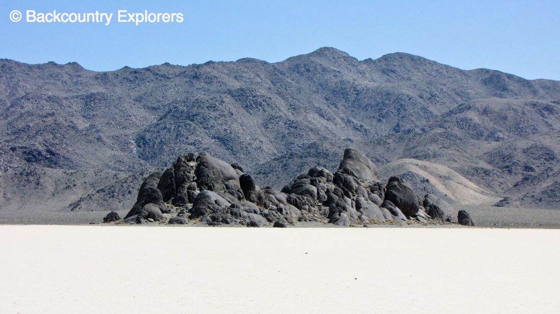
Grand Stand at Racetrack Playa
|
|
Resources: